
Fact sheet - Connectivity between water systems
What is connectivity?
When groundwater is extracted from an aquifer there are potential impacts on other water resources, depending on the duration and rate of extraction, and the connectivity (or degree of connection) between the water resources.
Connectivity refers to the degree of hydraulic interaction between aquifers, between different parts of the same aquifer, and between groundwater and surface water systems. It depends largely upon the lithology of geological strata, and their integrity and spatial continuity. Fractures, faults and open or inadequately-sealed boreholes can form preferential flow paths that also affect connectivity. The degree of connectivity and the rate of water flow between aquifers and water systems are strongly influenced by local and regional hydraulic pressure. As groundwater and surface water systems are dynamic, these gradients can change with time (DoE, 2014).
Connectivity can be considered in the context of groundwater flow paths. For example, groundwater flow in shallow aquifers is often constrained by local catchment boundaries. However, coal seam gas extraction occurs largely from deep coal seams that occur 300 metres or more below ground. At this depth, groundwater flow paths are more regional in nature, and impacts of groundwater extraction and depressurisation can spread beyond local catchments, subject to the connectivity between individual strata.
Connectivity is normally described as varying between low and high. Where there is high connectivity, water bodies are connected in such a way that there is a high transfer rate of water between them.
This fact sheet explains the significance of connectivity in managing the impacts of coal seam gas development and coal mining.
What creates connectivity?
Connectivity between two water systems is a function of both the permeability of individual geological formations, and hydraulic pressure which creates a driving force for water flow. Permeability includes both the interconnection between pores at a fundamental level within the rock (primary porosity – created as a consequence of the rock’s deposition) and fractures and joints in rock bodies (secondary porosity – created by tectonic forces after the rock was formed) (Fetter, 1988).
The main geological formations of interest in coal seam gas development and coal mining are sedimentary layers that can have both primary porosity and secondary porosity. Also of interest, particularly in coal mine dewatering, are sand and gravel alluvial aquifers that underlie the floodplains of rivers. These aquifers can have high levels of primary porosity, and enable high levels of connectivity between groundwater and surface flows (Figure 1).
The connectivity between water bodies can be increased by deteriorated or inappropriately constructed bores that provide a direct link between different aquifers, and by fracturing of strata in relation to underground coal mining. In coal seam gas areas, connectivity may also be increased through inappropriately conducted hydraulic fracturing (to establish coal seam gas production wells) and fracturing of strata in relation to subsidence from coal seam gas depressurisation.
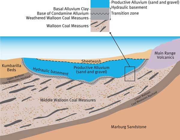
Figure 1. In the Surat Basin, Queensland, the Walloon Coal Measures are a major source of coal seam gas. In a part of the Basin they closely underlie the alluvial aquifers of the Condamine River, which are a major source of groundwater supply. Reduced pressure in the coal measures may enable leakage from the alluvial aquifer. The thickness and permeability of an intervening transition layer influences the degree of connectivity between the two units. Source: QWC, 2012.
Coal seam gas development and groundwater extraction
Coal seam gas development involves the construction of production bores into suitable coal seams, and extraction of groundwater from the coal seams at rates sufficient to lower the pressure within them and enable gas to be released. This gas is then pumped to the surface along with the groundwater.
Gas-bearing coal seams are typically located at depths of more than 300 m below ground. For gas to be released from coal seams, the water level in the coal formation is typically lowered to within 35 m to 40 m of the uppermost coal seam by pumping groundwater from the seam.
This can be as much as several hundred metres of drawdown. It may take up to five years of pumping to lower the water pressure to the required level for gas to be released. Pumping continues at the rate necessary to maintain water pressure at the target level until gas production declines to non-economic levels.
Coal mining and groundwater extraction
Coal mining involves the excavation and removal of coal from beneath the ground, which can occur by either:
- open-cut mining (removing the ground surface to then extract the coal), or
- underground mining (excavating coal seams from under the surface; this is commonly done in Australia at present by using the ‘longwall’ mining method).
If an open cut mine extends below the watertable, the watertable has to be lowered by extracting groundwater to enable work to proceed. This is often achieved through the use of strategically located dewatering bores.
Groundwater that is not extracted by dewatering bores, and flows into and collects in a mine, must also be removed, and is referred to as interception.
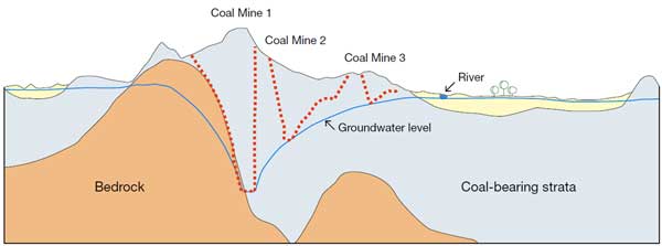
Figure 2. Conceptual cross-section of proposed coal mines and potential groundwater drawdown. Dewatering of aquifers has led to a drawdown of the groundwater level in the vicinity of the mines. This drawdown extends beyond the extent of the mines, and may impact on the adjacent river.
Connectivity implications
During coal seam gas development, the extraction of groundwater from the coal seams does not actually ‘dewater’ the coal seams or adjoining aquifers (they remain fully saturated, but under less pressure). However, the pressure reduction can impact on connected aquifers (Figure 1).
Groundwater interception and extraction for open cut mine dewatering lowers the groundwater level in the vicinity of the mine. A conceptual model of potential groundwater drawdown at adjoining open-cut coal mines is provided in Figure 2.
Underground mining also requires groundwater extraction, which can affect overlying aquifers and streamflow. In addition, planned collapse of longwall mine voids and subsequent fracturing of overlying strata can enhance vertical connectivity.
The extent to which the impacts of the extraction of groundwater may extend into adjoining water systems will depend largely on the duration and rate of interception and extraction, and the degree of both lateral and vertical connectivity of local aquifers. Impacts can include:
- increased leakage between aquifers, which may also allow migration of salts from saline to fresh aquifers and flow from water supply aquifers (Figure 1)
- reduced flow to springs and streams, and increased leakage from streams to groundwater
- compaction of strata, which may contribute to land subsidence
- reduced groundwater levels in other production bores in the area, which may increase the cost of groundwater access for other users, and may even prevent access.
Assessing connectivity
Connectivity between aquifers can be assessed using a range of methods including:
- groundwater level monitoring – to determine the direction and potential rate of groundwater flow (the latter also requires measured or assumed rock properties)
- aquifer tests – to determine aquifer hydraulic parameters, and to detect and analyse responses in adjacent aquifers
- geochemistry – to identify potential flowpaths between aquifers
- surface geology – by inspecting outcropping strata to assess primary porosity and degree of fracturing
- laboratory studies – including permeability tests on rock samples
- geophysics – using aerial (e.g. magnetics), surface (e.g. seismic) or down-hole techniques to identify rock properties and geological structures
- numerical models – to simulate flow conditions under current conditions and how these may change under different scenarios.
Connectivity between groundwater and surface water can be assessed using the following methods:
- groundwater and surface water level monitoring - to identify hydraulic head differences and subsequently the potential rate of flow using measured or assumed rock properties
- stream gauging – to detect differences in stream flow rates between stations, and identify possible losses to or gains from groundwater
- geochemistry and temperature monitoring – to detect flow between surface water and groundwater systems
- water balance assessment – to estimate bulk flow between surface water and groundwater
- numerical models – to validate water balance assessments, simulate flow conditions and identify how these may change under different scenarios.
Ideally, multiple methods should be used for any assessment of system connectivity. Numerical models in particular are frequently used to analyse and/or simulate groundwater flow conditions, including connectivity, and rely on any other available connectivity information in their development. They are valuable tools for validating connectivity interpretations and illustrating how this affects the migration of depressurisation and groundwater level drawdown between aquifers.
The connectivity between water resources controls the manner in which impacts may move between those resource systems. It is a fundamental property that needs to be considered whenever impacts are being assessed. It can be difficult to quantify, particularly within large regional groundwater systems and its quantification is one source of uncertainty in any assessment.
Future directions: knowledge gaps and strengthening the science
Specific modelling of individual coal mines and coal seam gas borefields is often required to predict how extraction may impact on local water resources, with a particular emphasis on groundwater systems, and to develop appropriate operating conditions. This process would benefit from further research and continual improvement in the following areas:
- understanding the influence of fractures and faults, and representing these features within groundwater models
- the role of aquitards in modifying or controlling flow and how the varying properties of these geological units can be simulated in models
- methods for estimating aquitard permeability and/or aquitard leakage at large scales
- the extent to which hydraulic properties and connectivity may change during coal seam gas development and coal mining operations
- the advantages and disadvantages of various groundwater modelling approaches
- interaction of the physical hydrology with dependent ecosystems, and how these ecosystems are impacted by changes in both groundwater and surface flows.
References
Australian Government (2014) Aquifer connectivity within the Great Artesian Basin, and the Surat, Bowen and Galilee Basins. Background Review, Office of Water Science, March 2014. Department of the Environment, Canberra.
Fetter, C. W. (1988) Applied Hydrogeology. Second Edition.
Queensland Water Commission (2012) Underground Water Impact Report for the Surat Cumulative Management Area.